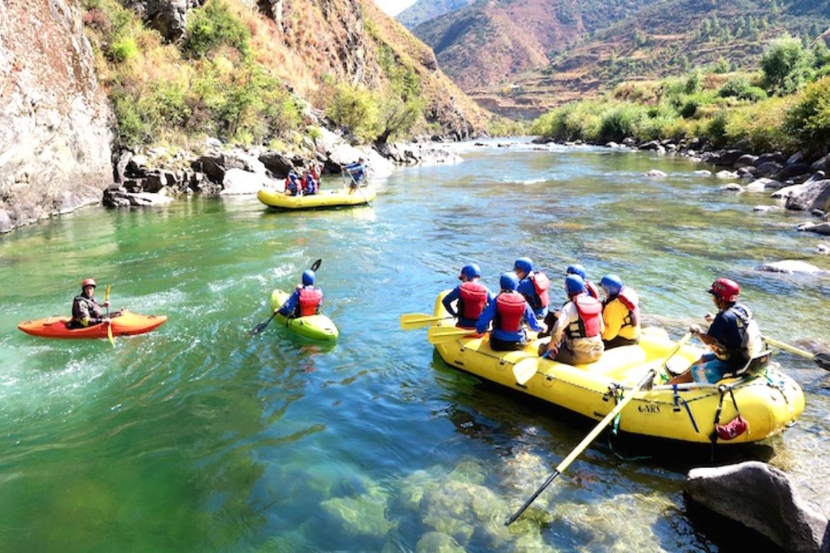
Center Part
- Location: Paro Valley, Western Bhutan
- From/To: Mitshi Zam – Satsam Chorten
- Length: Approximately 10 km, 3 hours
- Difficulty: Class III – IV
- Flow: About 500 cfs Mar/Apr, Nov/Dec. High water will make this much more difficult and is not recommended.
- Craft: Due to the very narrow and steep rapids Kayaks are recommended only.
Description: From Mitshi Zam, at the footbridge, the river is small and shallow with many class III and IV rapids that are formed where the river constricts. When the dirt road leaves the river, near Drukgyel Dzong, the river drops into Foot Freezer Gorge, a continuous class IV boulder choke about one kilometer long. After the gorge, the river opens up into class II for the rest of the way to the footbridge Satsam Chorten.
Places and attractions:
- Rinpung Dzong
- Drukgyel Dzong
- Taktshang
- Kyichu Lhakhang
- Kila Gompa
- Dungtse Lhakhang
- Tachog Lhakhang
- Dzongdrakha
Accommodation options:
- Location: Paro Valley, Western Bhutan
- From/To: South of Paro – Chuzom (confluence with the Thimphu Chhu)
- Length: 7 km, 1 hour
- Difficulty: Class II-III, with one V
- Flow: Approximately 500 cfs.
- Craft: Kayaks only as the river is too small for a raft to be enjoyable.
Description: The lower Paro Chhu river is a good stretch for beginner/intermediate kayakers, there are plenty of small, boulder rapids and wave trains. There is one class IV -V boulder choke, about 3 km from the put-in, which can be run on the left and scouted from the right. After this, the river enters a short, scenic canyon with more class II – III rapids. Take out at the road bridge at Chuzom, or for the more experienced kayakers, head down the Wang Chhu.
Places and attractions:
- Rinpung Dzong
- Drukgyel Dzong
- Taktshang
- Kyichu Lhakhang
- Kila Gompa
- Dungtse Lhakhang
- Tachog Lhakhang
- Dzongdrakha
Accommodation options:
- Location: Thimphu/Paro/Phuntsholing, Western Bhutan
- From/To Chuzom – Below Tam Chhu
- Length: Approximately 4 km, 2 hours
- Difficulty: Class IV, one class V
- Flow: 800 -1000 cfs Mar/Apr, Nov/Dec. High water in this section would be extremely dangerous and is not recommended.
- Craft: Kayaks only.
Description: The Wang Chhu from Chuzom is continuous and full of ledges and boulder sieves. It is a bad place to swim, washing into the wrong channel could be lethal. For solid class IV paddlers, it is a really fun paddle with lots of complex rapids and steep creek-style paddling. Below the bridge at Chuzom, there is a 6-foot waterfall, which should be scouted from the right. After this is about 2 kilometers of continuous class IV rapids, with a few that should be scouted. The river opens up a bit and eases off, before going into one last class IV section. Following this, the road comes down close to the river again offering a place to take out.
Places and attractions:
- Rinpung Dzong
- Drukgyel Dzong
- Taktshang
- Kyichu Lhakhang
- Kila Gompa
- Dungtse Lhakhang
- Tachog Lhakhang
- Dzongdrakha
Accommodation options:
- Location: Thimphu/Paro/Phuntsholing, Western Bhutan
- From/To Tam Chhu – About 4 km down
- Length: 4 km, 1 hour
- Difficulty: Class III
- Flow: 800 -1000 cfs Mar/Apr, Nov/Dec. A high water run may be possible if scouted carefully. Craft: Kayaks, Rafts
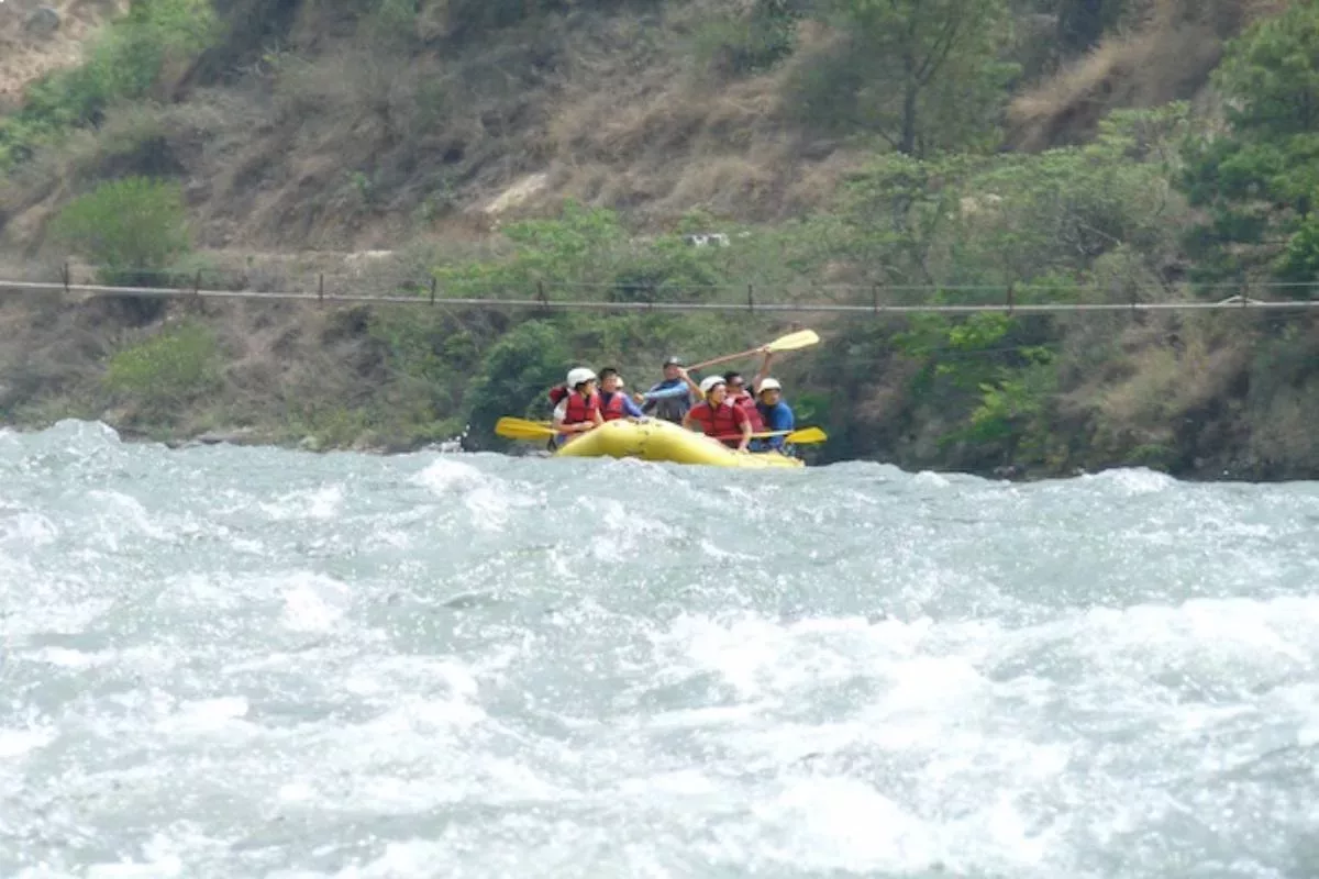
- Description: The lower section of the Wang Chhu opens up and is considerably easier than the upper section, with plenty of class III wave trains. This is a good section for rafts, or an alternative put in for beginner/intermediate kayakers. Take out at the big sandy beach on the river left, and walk uphill to the road.
Places and attractions:
- Rinpung Dzong
- Drukgyel Dzong
- Taktshang
- Kyichu Lhakhang
- Kila Gompa
- Dungtse Lhakhang
- Tachog Lhakhang
- Dzongdrakha
Accommodation options:
- Location: Punakha Valley, Western/Central Bhutan
- From/To Wangthangka (a two-hour trek from the end of the road) – Samdingkha.
- Length: Approximately 7 km, 2 hours with scouting Difficulty: Class III-IV
- Flow: 2000 -3000 cfs Mar/Apr, Oct/Nov. High water in this section will make this run very difficult.
- Craft: Kayaks and Rafts
- Description: The upper Pho Chhu (Pho Chhu means “Male River”) is a great paddle through an open valley, and well worth the walking time. There are a few good class IV rapids at the top, full of big boulders and big water moves. There is a good put in, just above the footbridge at Wangthangka. Immediately below the put in, the first class IV rapid can be scouted from the left. After this, go around the comer and under the footbridge and scout the next class IV from the left. From here, most of the rapids are boat scoutable as the river eases up a bit, and there is lots of big, bouncy class III rapids and a few boulder gardens. Take out at the footbridge at Samdingkha, or continue another 7 km down to Punakha.
Places and attractions:
- Punakha Dzong
- Khamsum Yulley
- Talo Goenpa
- Nalanda Buddhist College
- Chorten Nyingpo Lhakhang
- Sangchen Dorji Lhuendrup
- Limukha Village
- Ritsha Village
Accommodation options:
- Location: Punakha Valley, Western/Central Bhutan
- From/To Samdingkha – Punakha (directly below the Mo Chhu confluence)
- Length: 7km, 1.5 hours
- Difficulty: Class III with one IV at the bottom
- Flow: 2000 -3000 cfs Mar/Apr, Oct/Nov. Should be runnable in high water.
- Craft: Kayaks and Rafts
Description: The lower Pho Chhu (Pho Chhu means “Male River”) is much easier than the upper section, with plenty of class III and a good class IV finale. This is currently the most popular rafting tour since it is not too difficult and is a beautiful half-day raft trip. From Samdingkha, the river meanders through a wide-open valley, full of rice fields and farmhouses.
About 4 kilometers down is Strainers Paradise, a class III boulder choke. From here, there are some nice wave trains until the grand finale. Right below Bhutan’s longest footbridge is Wrathful Buddha, a class IV. Take out is right after the confluence with Mo Chhu, next to the impressive Punakha Dzong.
Places and attractions:
- Punakha Dzong
- Khamsum Yulley
- Talo Goenpa
- Nalanda Buddhist College
- Chorten Nyingpo Lhakhang
- Sangchen Dorji Lhuendrup
- Limukha Village
- Ritsha Village
Accommodation options:
- Location: Punakha Valley, Western/Central Bhutan
- From/To Tashitang (end of the road, about 2-hour’s drive from Punakha) – Punakha Dzong (directly below the Pho Chhu confluence)
- Length: 12 km, 5 -7 hours with scouting
- Difficulty: Class V
- Flow: 1000 cfs, Feb/Dec. Higher than medium flows will make this run dangerous. A high water run is not recommended.
- Craft: Kayaks only, this is much too difficult and steep for a raft.
Description: The upper Mo Chhu (Mo Chhu means “Female River”) from Tashitang has lots of class V, with a gradient of about 300 feet per mile. There is a short stretch of flat water about six kilometers down, the end of which marks the start of the Devil’s Gorge, a step up from the whitewater above.
There is little access to the road, so paddlers attempting this section of the river should be ready to commit to the whole thing. For those, not want to bite off such a big chunk of hard whitewater, check out the alternative put in for the upper stretch, described below (Mo Chhu – Upper Run).
Places and attractions:
- Punakha Dzong
- Khamsum Yulley
- Talo Goenpa
- Nalanda Buddhist College
- Chorten Nyingpo Lhakhang
- Sangchen Dorji Lhuendrup
- Limukha Village
- Ritsha Village
Accommodation options:
- Location: Punakha Valley, Western/Central Bhutan
- From/To 14 km above Punakha – Khamsum Yulley Bridge
- Length: 3 km, 1.5 hours with scouting
- Difficulty: Class IV -V
- Flow: 1500 – 2000 cfs, Mar/Apr, Nov/Dec
- Craft: Kayaks only, too difficult for a raft.
Description: From this put in the gradient reduces slightly, although the rapids are still continuous class IV with several classes Vs. which may need scouting. At the put-in, the first rapid, Whiplash, can be scouted from the river left. After Whiplash, the river continues to drop away in horizon line after horizon line. After about two kilometers, there is a short piece of flat water, recognizable because it is the only flat water in this section. This marks the start of a long, two-part class V rapid called Paula Jones. About one kilometer of class IV remains after Paula Jones, and the section ends with Baba Raj, a class IV that can be scouted from the left. Take out here, or continue downstream.
Places and attractions:
- Punakha Dzong
- Khamsum Yulley
- Talo Goenpa
- Nalanda Buddhist College
- Chorten Nyingpo Lhakhang
- Sangchen Dorji Lhuendrup
- Limukha Village
- Ritsha Village
Accommodation options:
- Location: Punakha Valley, Western/Central Bhutan
- From/To Khamsum Yulley Bridge – Khamsum Yelling Namgyel Chorten
- Length: 5 km, about 1.5 hours
- Difficulty: Class III – IV
- Flow: 1500 – 2000 cfs, Mar/Apr, Nov/Dec. Might be runnable at higher flows if scouted carefully. Craft: Kayaks and Rafts
Description: From Khamsum Yulley Bridge Put In, the river eases into pool drop class III and IV and offers a good place to put in for a raft or intermediate kayakers. At the put-in, there is a class III rapid that leads into the class IV rapid, Kingpin. Run the class III, then get out and scout on the left.
There are a couple of class IV wall rapids after this, then the river continues with lots of pool drop class III until after the S -Bend, which you can see from the road. A one-boulder choke remains, which is runnable down the left. Take out below the temple, which was recently constructed on the river right, below the footbridge.
Places and attractions:
- Punakha Dzong
- Khamsum Yulley
- Talo Goenpa
- Nalanda Buddhist College
- Chorten Nyingpo Lhakhang
- Sangchen Dorji Lhuendrup
- Limukha Village
- Ritsha Village
Accommodation options:
- Location: Punakha Valley, Western/Central Bhutan
- From/To Khamsum Yelling Namgyel Chorten – Pho Chhu confluence
- Length: 6 km, 1 hour (high winds in the spring can make this stretch much longer, as there is little current to carry you downstream).
- Difficulty: Class I – II
- Craft: Kayaks, Rafts, Bath toys, and anything that floats
Description: This section is a good place for beginner kayakers, since there are plenty of eddies and small wave trains, but not enough current to be pushy at all. It is also a great scenic raft trip for folks who don’t want too much excitement and appreciate the novelty of floating past the Punakha Dzong.
Places and attractions:
- Punakha Dzong
- Khamsum Yulley
- Talo Goenpa
- Nalanda Buddhist College
- Chorten Nyingpo Lhakhang
- Sangchen Dorji Lhuendrup
- Limukha Village
- Ritsha Village
Accommodation options:
- Location: Wangdue Phodrang, Western/Central Bhutan
- From/To: From Wangdi 7 km downstream – Kichu Resort
- Length: Approximately 3km, 2 hours with scouting
- Difficulty: Class IV -V at medium flows, V -V at higher flows
- Flow: 400-500 cfs Mar/Apr, Oct/Nov. High water will make this run lethal.
- Craft: Kayaks only, too small, too steep, and too difficult for a raft.
Description: From the bridge, there is about 2km of pool drop class IV warm-up until the first major class V. It is about 500m long and drops an average of 300 feet per mile. It is very technical, and a swim in any part of it could be disastrous. Scout from river left. After this, the river continues to drop steeply, but the rapids are shorter and there are pools below them. Any horizon line should be scouted, as there are several pinning possibilities and lots of other places you wouldn’t want to be.
Places and attractions:
- Dargay Goemba
- Gangtey Gompa
- Temple Of Sha Radap
- Gaselo & Nahee Village
- Adha And Rukha Village
- Shaa Region Of Wangdiphodrang
- Bhey Langdrag Nye
Accommodation options:
- Location: Wangdue Phodrang, Western/Central Bhutan
- From: Kichu Resort – 5km downstream of Dang Chhu
- Length: 5km, 1.5 hours
- Difficulty: Class IV with 3 class V scouts
- Craft: Kayaks, a raft would be possible, but only with a strong team, several portages for rafts. It would be very time-consuming, and there are other more rewarding rafts runs in the area.
Description: Right below the Kichu Resort is a class V drop that is runnable on the left, scout from either side. The river gorges in before the next rapid, scout on the right. Following this are several other class IV rapids, most are boat suitable. There is a major boulder choke, which can be run far left.
The last major class V is a tight squeeze between two boulders. Scout this one carefully – from the left, as there may be a log jammed underwater directly below the crux move. After this, there are a few more horizon lines, then the river eases up a bit and becomes the lower run. There is a possible takeout where the lower run begins, but it’s a long walk up and a short paddle down.
Places and attractions:
- Dargay Goemba
- Gangtey Gompa
- Temple Of Sha Radap
- Gaselo & Nahee Village
- Adha And Rukha Village
- Shaa Region Of Wangdiphodrang
- Bhey Langdrag Nye
Accommodation options:
- Location: Wangdue Phodrang, Western/Central Bhutan
- From/To: 5 km upstream from Wangdi Phodrang – Puna Tsang Chhu confluence
- Length: Approximately 5km, 1 hour
- Difficulty: Class III+
- Flow: Class IV with 3 class V scouts. Runnable at high water if the first section is scouted carefully and the paddlers are strong.
- Craft: Kayaks and Rafts
Description: From the trail leading to the river, there is one continuous boulder class III+ rapid. It is very technical and can present some difficulty to beginner kayakers, as there are very few eddies and it’s hard to stop. After this, there are a few more class three rapids, then the river flattens out and becomes class II to the confluence. Take out on the river right after the confluence with the Puna Tsang Chhu.
Places and attractions:
- Dargay Goemba
- Gangtey Gompa
- Temple Of Sha Radap
- Gaselo & Nahee Village
- Adha And Rukha Village
- Shaa Region Of Wangdiphodrang
- Bhey Langdrag Nye
Accommodation options:
- Location: Wangdue Phodrang, Western/Central Bhutan
- From/To: Kami Chhu – Waklaytar Bridge
- Length: Approximately 15km, 4 hours in a kayak with scouting, longer for a raft due to portages.
- Difficulty: Class IV-V at low to medium flows, solid Vat high flows.
- Flows: 5000 – 7000 cfs Mar/Apr, Nov/Dec. High water will be extremely difficult, and not recommended.
- Craft: Kayaks. Rafting would be possible, but only with a strong crew.
Description: From the Kami Chhu, the river eases off a bit and offers a chance to paddle some big rapids in a more reasonable setting. There are many class IV pool drop rapids and two major class Vs. before the confluence with the Hara Chhu, from the left. The first class V is recognizable by a large boulder choke, which may or may not be runnable through a sneak chute on the right. Scout from river right. For rafts, this will probably need to be portaged, as there is a long lead and the sneak chute is pretty tight.
The second class V is a couple of kilometers below, where there is a large landslide coming in on the left. This one is not so easy to recognize, and if not paying attention, an unlucky paddler could find himself committed to running the large hole at the bottom. After the Hara Chhu, there are still several big class IV rapids, most of which can be scouted from a kayak. A raft team will probably need to do more scouting.
Places and attractions:
- Dargay Goemba
- Gangtey Gompa
- Temple Of Sha Radap
- Gaselo & Nahee Village
- Adha And Rukha Village
- Shaa Region Of Wangdiphodrang
- Bhey Langdrag Nye
Accommodation options:
- Location: Wangdue Phodrang, Western/Central Bhutan
- From/To Waklaytar Bridge – Sunkoshtar
- Length: Approximately 17km, 4 hours
- Difficulty: Class III-IV at most flows.
- Flows: 5000 – 7000 cfs Mar/Apr, Nov/Dec. High water will make this run much more difficult, but more reasonable, than the canyon stretch.
- Craft: Kayaks and Rafts
Description: This is a beautiful section of the river that is ideal for a one-day raft trip or kayak trip. It can also be extended to make a two-day raft trip. Almost all the rapids are scoutable from a kayak, although there are some large holes, so if you can’t see downstream, get out and take a look. At Waklaytar, there is an amazing surf wave on the river left when the water is at the right level.
Downstream, the river starts with a few big, bouncy class III rapids, before going around a left-comer into the first big rapid, Tata Stopper, which features a huge, but the easily avoidable hole on the river’s right. Run left. After a couple more comer rapids are Momma Mia, a sharp right turn with a big hole in the middle. Run either left or right of the hole, scout left. This marks the start of the hardest section of the river. Following Momma Mia, there are three more class IV rapids that need to be scouted, including Ara Ura and Rich and Famous.
The river continues with some nice pool drop rapids down to the Buri Chhu coming in from the river left, a possible put-in or take-out if you’re looking to cut the run a little shorter. Immediately after the Buri Chhu is Two Girlfriends, runnable down the right through the two big holes. One major rapid remains, a boulder choke called Bupen Falls, scout from the left, stay away from the right. Several more rapids and about 4 kilometers remain before reaching the takeout at Sunkoshtar. An alternative takeout would be at the river camp at Changchey, about one kilometer above Sunkoshtar.
Places and attractions:
- Dargay Goemba
- Gangtey Gompa
- Temple Of Sha Radap
- Gaselo & Nahee Village
- Adha And Rukha Village
- Shaa Region Of Wangdiphodrang
- Bhey Langdrag Nye
Accommodation options:
- Location: Trongsa, Central Bhutan
- From/To 2 km upstream from Yindocholling Palace – Langtel
- Length: Approximately 5km, 2 hours with scouting
- Difficulty: Continuous class IV in Mar/Apr, Nov/Dec
- Flows: Approximately 3000 cfs in Mar/Apr, Nov/Dec
- Craft: Kayaks
Description: From the put-in, the river goes right into continuous class IV and doesn’t let up until the footbridge. The rapids are long, boulder, and full of technical moves. The river is steep and powerful, and being offline can land you in some big holes. There are approximately five scouts, depending on the water level and the boater’s ability. While many of the rapids can be scouted from a kayak, the more you scout, the less likely you are to find yourself stuffed into a rock or surfing a big hole.
Places and attractions:
Accommodation options:
- Location: Bumthang, Central Bhutan
- From/To: Thankabi – Jakar
- Length: 5 km, 1 hour
- Difficulty: Class II -III
- Flows: 1500 cfs, Mar/Apr, Nov/Dec
- Craft: Kayaks and Rafts
Description: The river from Thankabi is mostly a float through the scenic Bumthang valley. At Thankabi, kayakers can put in on the small side creek and paddle about 500m to the confluence with the Chamkhar Chhu. The river starts with a few class III rapids, then the valley opens up and the river flattens out to class II. This would be an excellent half-day raft trip for tourists visiting Bumthang who want to view the Dzong and monasteries from a different perspective.
Places and attractions:
Accommodation options:
- Location: Bumthang, Central Bhutan
- From/To: Misitang – Jakar
- Length: 10 km, 2 hours
- Difficulty: Class III-IV (including one of the only class VI pieces of flatwater in the world)
- Flows: 300 -500 cfs Mar/Apr, Nov/Dec. High water runs are not recommended
- Craft: Kayaks only, the rapids in the lower section are too narrow to allow a raft to pass. Portaging is not an option.
Description: The Tang Chhu is a beautiful river, running through the remote and seldom visited Tang valley. Put in at Misitang, where an impressive monastery sits against a diff on the river’s right side. A road is under construction here and it may be possible in the future to drive higher up the valley. From the put-in, there is about 6 km of class II as the river meanders through the wooded river valley. Even though the road is not far away, this river feels extremely remote, as we have never seen any other people while paddling down.
As the river bank starts to get steeper, the river enters a steep-sided canyon, and the rapids become more technical. It is recommended to scout anything that you can’t see, as there is a lot of wood in this river, and strainers are not uncommon. There is one rapid towards the bottom of the gorge that should be scouted. Look for a boulder choke with a sharp horizon line and a big wall on the right. Scout from the right. This rapid runs out into a short, sheer-sided gorge, which sometimes has a log wedged in it sideways.
If the water is low enough, kayakers should be able to duck under the log and continue downstream. If the water is high enough, a portage may be necessary. Directly downstream from the gorge, a short class II rapid leads into the Burning Lakes. Take out at the top of the rapid on the river left, don’t miss it! Even though the Burning Lakes is flat water, it is a very sacred place and must be portaged. It should be easily recognizable by two sheer walls, an abundance of prayer flags, and a small footbridge crossing the river.
Walk around to the other side of the Burning lakes and put in downstream. One rapid remain, a five-foot drop between some boulders into a big pool. Scout from the left. Be careful here, as the hydraulic at the bottom of the drop is a nasty one, and high water could make it very dangerous. Take out at the road bridge downstream.
Places and attractions:
Accommodation options:
- Location: Lhuentse, Central-Eastern Bhutan
- From/To Lhuentse – 14km downstream
- Length: Approximately 14km
- Difficulty: IV for the first 7 km, class V -VI after that
- Flows: 4000 -6000 Mar/Apr, Nov/Dec. High water runs are not recommended
- Craft: Kayaks only. The long portages and big rapids in the lower canyon would make this impossible for a raft.
Description: From the put-in, we found the river to be big volume, pool drop class IV for about 7 km. The rapids are full of big boulders and big water, technical moves, similar to the lower Puna Tsang Chhu from Waklaytar Bridge. After 7 km, a small side stream enters from the river left, offering a good possibility for a take-out point, because after this the road leaves the river.
There’s a reason for this! At this point, the river enters a deep canyon and the gradient increases dramatically. Several huge landslides come in from both sides of the river, creating massive, complex rapids. The first one is called Skin of Your Teeth, a long, solid class V. Scout carefully from the left, as different water levels could make this rapid runnable. After this, the rapids continue, and we found ourselves either portaging over house-sized boulders or running class V sneak routes around class VI drops.
This is very hard work and stressful. It took four hours to negotiate the 3 kilometers that made up the toughest part of the canyon, and we portaged 3 times. After the main canyon, there are about 4 kilometers of class IV, with one class VI portage. Take out where the footbridge crosses the river, and walk up the footpath for about 20 minutes, or for those who don’t want to walk, continue downstream through the next section.
Places and attractions:
- Dungkar Naktshang
- Kishuthara
- Varied Flora And Fauna
- Jangchubling
- Khiney Lhakhang
- Wangzhing Lhakhang
- Shazo In Minjey
- Singye Dzong
Accommodation options:
- Location: Lhuentse, Central-Eastern Bhutan
- From/To: Bottom of the upper canyon – South of Austho Village
- Length: Approximately 20 km, 3-4 hours
- Difficulty: Class IV-IV+ with a couple of class Vs
- Flows: 4000 -6000 Mar/Apr, Nov/Dec. High water runs are not recommended
- Craft: Kayaks and Rafts
Description: From the footbridge at the bottom of the upper canyon, the river eases off and becomes much more runnable. The rapids are much like the first seven kilometers of the upper section; big volume, pool-drop, with many big boulders and technical big water moves. Several class IV moves need scouting. The road parallels the river for the first 13 km down to the village of Austho.
For intermediate paddlers, this is a good takeout, because the river jumps up a grade after this, and the road winds away from the river. Just downstream from Austho, a big class IV+ is running up against a sheer diff on river right. This should be visible on the drive-up. Scout from the left. Directly downstream is another big rapid that can be scouted from left or right.
As the road winds away, the river drops into a beautiful canyon for about 7 kilometers. The rapids from here are still pool drop, but they are more difficult, class IV+ and V, and many require scouting. There is a big flat spot next to the road on the river left which makes a great campsite and takeout for this section. Downstream, the river drops away into another class V-VI gorge.
Places and attractions:
- Dungkar Naktshang
- Kishuthara
- Varied Flora And Fauna
- Jangchubling
- Khiney Lhakhang
- Wangzhing Lhakhang
- Shazo In Minjey
- Singye Dzong
Accommodation options:
- Location: Lhuentse, Central-Eastern Bhutan
- From/To Powerhouse – Hydropower Project Site
- Length: Approximately 10 km, 1 hour
- Difficulty: Class III
- Flows: 4000 -6000 Mar/Apr, Nov/Dec. High water runs are not recommended
- Craft: Rafts and Kayaks
Description: A German group paddled led by this stretch in early October 1999 when the water levels were very high and reported it to be mostly class III. This can be confirmed by road scouts. A road continues south of the East-West Road Bridge for about 6 kilometers and parallels the river dozily for most of the way. At the end of the road is a large hydropower project, which will create a reservoir that will back the river up some six kilometers, making most of this lower run a flat water paddle.
Places and attractions:
Accommodation options:
- Inclusion
- Exclusion
- Insurance
- Airport pick-up and drop-off by private vehicle.
- 3-star accommodation (4 & 5 stars may require an additional premium update).
- Bhutan visa fee – including all necessary processing
- Route Permit
- Three meals per day during your stay in Bhutan
- A licensed Bhutanese tour guide
- All land transportation by private vehicle
- Camping equipment and haulage for trekking tours
- Sightseeing as per itinerary
- Monuments entrance fees where applicable
- Drinking water
- All internal taxes and charges
- A sustainable development fee of $200. (This sustainable development fee goes towards free education, free healthcare, and poverty alleviation, along with the building of infrastructure.)
- Airfare & Travel Insurance
- Expenses of personal nature, Tips to guides and drivers
- Expenses occurred due to unavoidable events i.e. road wrecks, flight delays etc.
Package does not include insurance of any kinds, and that you are required to obtain separate coverage from your home country before your trip begins.